#1 Costa Rica Travel in Paradise, Costa Rica Vacations |
|
|
||||||||||||||||
|
Home| Escorted Trip | Family Trip | Honeymoon |Tailor MadeTours | Rent a Car | Hotel | One Day Tours| About C R| Testimonial | FAQ | Contact Us | About Us | Terms| How to Book
|
||||||||||||||||
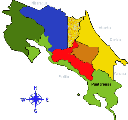
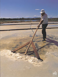
Climate: Being Costa Rica's largest province (11,277 sq. km.), Puntarenas includes practically all of the climate regimes found in this small, but tremendously varied, country. From tropical dry forest to rain forest, and from mangrove swamp to cloud forest to subalpine paramo, this sprawling province contains at least a little bit of everything. Although the entire province lies on the Pacific side of the continental divide, much of its land area is not as severely affected by the annual dry season as is most of Guanacaste province (just to the north on the same side of the country). This is due to the topography's effect on the prevailing winds. The northeast trade winds that come in off the Caribbean Sea are to some extent blocked by the higher mountains of the Central Volcanic and Talamanca Cordilleras before they reach much of the province (from the Carara Biological Reserve south); and once on the Pacific side, the turbulence formed in the passage results in a vortex, or reverse flow of air currents, that actually can draw in moist air from the Pacific Ocean and produce scattered rain showers even during the dry season. These occasional rains and associated high humidity keep the forested portions of the southern coastal areas (e.g., Manuel Antonio and Corcovado National Parks) green throughout the year, though some species of trees do briefly drop their leaves in response to the drier conditions from January through April.In the interior sections of the province that reach up to the ridgeline, luxuriant cloud forests exist owing to the mists that sweep across the mountaintops when the tradewinds' full effect is felt from December through February. Yet it is saddening to see how deforestation has advanced up the steep hillsides, in large part aided by the ease of burning the natural vegetation during the dry months of March and April.History: The peculiar shape of Puntarenas province has a very sensible explanation. During the first 350 years of Spanish presence in Central America, the southern Pacific portion of what is now Costa Rica remained quite isolated from the developing population centers of the region. The high mountains between this area and the Central Valley presented a formidable barrier to the available means of terrestrial transportation. Thus, the few early settlers that ventured into the southern region came either from Panama to the south, or by boat from the port of Caldera in the Gulf of Nicoya. The dimensions of the province are due to the fact that it includes all the many kilometers of coastline from the Gulf of Nicoya south to Panama, the large inland valleys of Coto Brus and El General, and the southern tip of the Nicoya Peninsula -- all areas that were once most easily approached by sea.Despite the use of the Gulf of Nicoya as an entryway to Costa Rica's inland territory, the port of Puntarenas was not developed until 1840 when coffee production in the highlands reached exportable volumes. Originally, the coffee was brought to port in oxcarts via a trail through the mountains. In 1879, a stretch of railroad track was completed which connected Puntarenas with the town of Esparza (one of the country's earliest Spanish settlements, founded in 1554, a decade before the Central Valley began to be colonized) where the oxcart trail came out of the mountains. Eventually, the railroad was built all the way through to San José and service was inaugurated in 1910.With the railroad connection to the Central Valley, the Pacific port's activities continued to be a major part of the region's economy throughout the 20th century. However, due to the aging and deterioration of the port facilities and the need to accommodate the much larger vessels of modern shipping fleets, a new port was constructed in the 1980's to the south of Puntarenas. The site chosen was Caldera, where ships had anchored during colonial times.Prior to the Spaniards' arrival, the area that is now Puntarenas province was home to numerous groups of native peoples with varied lifestyles depending on the habitats in which they lived. The coastal inhabitants were no strangers to the sea and ventured out into open water either in dugouts or in balsa wood rafts. In addition to fish, they harvested other marine products such as shellfish (dug from the mudflats at low tide), sea turtles and turtle eggs, and murex shells from which they obtained a purple dye used in tinting cloth.The greatest of the Costa Rican pre-Columbian mysteries comes from the southern part of the province, near the towns of Palmar Norte and Palmar Sur, where hundreds of large stone spheres have been found. The largest of these granitic boulders measures 2.5 meters in diameter and weighs 13,000 kg. Many, however, are not much larger than bowling balls. How these nearly perfectly spherical stones were shaped with such precision is still a matter of speculation, as is their usage by the indigenous inhabitants of the region.Unfortunately, the chance for archeological interpretation of the spheres was forever lost when the aforementioned area was converted into banana plantations and bulldozers moved the stones from where they had been placed long ago by the natives. Settlement of the southern sector of the province was slow in coming, despite periodic expeditions into the region during colonial times. Thus, this area, together with the eastern slopes of the Talamanca Cordillera, was one of the last strongholds of indigenous culture in Costa Rica.Not until 1870 was a horse trail put through from the Central Valley to the Valley of El General. However, given the difficulty in traveling to this new frontier, colonization did not immediately follow the construction of this trail. In fact, the southern part of Puntarenas province remained sparsely populated by non-natives until the mid-1930's when banana plantations in the Caribbean lowlands were severely affected by a fungal infection known as "Panama disease" leading the United Fruit Co. to abandon those areas and look for somewhere to begin new plantations.The heat and high rainfall of the southern Pacific lowlands made for an ideal banana-growing climate (again, as in the Caribbean, at the expense of vast areas of tropical rain forest), and so it was that between 1936 and 1955 this area experienced an unprecedented wave of human impact.Ports were built in the banana company towns of Quepos and Golfito for the purpose of shipping the fruit to markets. The construction of the PanAmerican Highway from San José to Panama in the 1940's further opened the region to agricultural colonization by independent Costa Rican farmers.In the mid-1950's, disease in the banana plantations again caused serious problems for the local economies that were dependent on the production of this crop. Along the coast to the north and south of Quepos, the banana company actually destroyed the banana plantations and converted them to fields of African oil palm. These are still active today (and still expanding) and produce a vegetable oil used in cooking as well as oils used in cosmetics. An important aspect of the provincial economy today is tourism. The country's most popular beach resorts, Puntarenas (including Doña Ana and Barranca beaches), Jacó, and Manuel Antonio, are all found in this province, as are 14 national parks and reserves -- more than in any other province.
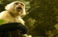
National Parks: 1) Peñas Blancs National Wildlife Refuge 2) Guayabo, Negritos and Pájaros Islands Biological Reserves 3) Curú National Wildlife Refuge 4) Cabo Blanco Absolute Nature Reserve 5) Carara Biological Reserve 6) Manuel Antonio National Park 7) Ballena Marine National Park 8) La Amistad International Park 9) Corcovado National Park 10) Caño Island Biological Reserve 11) Golfito National Wildlife Refuge 12) Cocos Island National Park Other Points of Interest: 1) Monteverde Cloud Forest Reserve: Settled by North American Quakers in the early 1950's, the montane dairy community of Monteverde has become a veritable ecotourist Mecca due to the presence of the Monteverde Cloud Forest Reserve (a private reserve owned and operated by the Tropical Science Center). Established in 1972, the Cloud Forest Reserve protects habitat for one of the world's most handsomely plumaged birds -- the Resplendent Quetzal. Noted for their shimmering green and red coloration and the elongated tail coverts of the adult males, quetzals are seasonally abundant in the reserve and community area (December through August), but many other bird and mammal species can also be seen with relative ease throughout the year, among them are the Emerald Toucanet, Collared Redstart, Blue-crowned Motmot, Black Guan, Hoffmann's Two-toed Sloth, Kinkajou, and half a dozen or more species of dazzling hummingbirds. Although, the chance to walk through this nearly enchanted, often mist-enshrouded environment and admire the epiphyte-laden vegetation of the cloud forest is worth the visit alone.A diverse and well-maintained trail system allows visitors to explore a small percentage of the reserve's total 11,000 ha. without feeling crowded. (NOTE: The hummingbird show at the Hummingbird Gallery (on the left just before the reserve parking lot) is free and nothing short of amazing. At least six species can be seen in a ten or fifteen minute viewing span on any day of the year, but you can easily find yourself lingering a lot longer as these feathered fireballs zip back and forth between the feeders and frequently hover just inches away from you.)Getting there: From San José, take the PanAmerican Highway west for nearly 150 km. until the turnoff for Monteverde, on the right just before coming to the bridge over the Río Lagarto. Continue on the gravel road for 35 km. to reach your destination.Approximately 4 hours drive from San José, the last 90 minutes or so over gravel road are dusty in the dry season (December through April) and can be muddy in the wet season. Most car rental companies will insist that you take a 4x4 if you are going to visit Monteverde. Climate: Monteverde residents refer to three seasons: dry, wet, and misty. The misty season (mid-November through February) is actually the first half of the dry season and is characterized by wind-driven clouds that bathe the forest, and frequently the community, in mists as they are blown across the ridgetop from the Atlantic side of the country. A poncho is definitely recommended during this portion of the year, while an umbrella should do fine for the afternoon rains that typically fall from May through November. Sweaters will handle the evening chill on almost any night of the year. Daytime temperatures vary with cloud cover and wind conditions, so layers are the best suggestion, but on a calm, sunny day shorts and shirt sleeves would be suitable. History: Looking for an alternative to the increasingly militaristic U.S. society, a group of 44 Quakers from Fairhope, Alabama pulled up stakes in 1950 and came to Costa Rica -- a nation which had taken the bold measure of abolishing its armed forces two years earlier in 1948. After visiting a number of highland areas the length of the country (climates unaffected by many of the more troublesome tropical diseases that were still a problem in the lowlands at the time), the group decided to settle in Monteverde and purchased 3,000 acres of land near the top of the ridge overlooking the Gulf of Nicoya below. To support themselves with something more than mere subsistence farming, they formed a cooperative cheese factory to take advantage of the excellent natural conditions for dairy farming, but nearly impossible conditions for transporting fresh milk to the San José market. Today, Monteverde cheese is renowned throughout Costa Rica and is also exported. 2) Santa Elena Reserve: In response to the growing numbers of visitors to the Monteverde Cloud Forest Reserve, this reserve was created in the early 1990's, just a few kilometers to the northwest along the same mountain chain. The cloud forest habitat that it protects is quite similar to that found at the neighboring reserve, as is the associated wildlife, including Resplendent Quetzals. One unique possibility at the Santa Elena Reserve, if the clouds permit, is to view Arenal Volcano. Even though the volcano is some 20 kilometers distant from the view points, it is still an imposing spectacle. The reserve is owned and managed by the Santa Elena Agricultural High School and the trails were constructed with high school volunteers from the Canadian Youth Challenge organization. To get there, take the dirt road out of Santa Elena towards Tilarán and bear right at the first fork beyond the soccer field. Four-wheel-drive could be necessary from May to February.
3) Robert & Catherine Wilson Botanical Garden: Now owned and administered by the Organization for Tropical Studies, the garden was begun in 1963 by its namesakes and portions were landscaped by the famous Brazilian landscape architect, Roberto Burle-Marx. The Wilsons originally attempted to grow tea on the property, but with coffee already an established crop in the region, local people weren't interested. Having formerly run a garden in Miami, this was a natural alternative. The Wilsons' fondness for certain plant families reveals itself in the large collection of palms, bromeliads, heliconias, aroids, marantas, and ferns assembled over the years on the 10 hectares of cultivated area. An adjoining 145-hectare tract of premontane wet forest, the largest remaining patch in the region, adds to the garden's attractiveness. Some 220 bird species, 80 mammal species, and 71 species of reptiles and amphibians have been identified on the property. At about 1,000 meters above sea level, the daytime temperatures in the garden are warm and evenings are cool. The area receives an average of 4 meters of rain per year, mostly from May through November. From the town of San Vito, drive south to the village of Agua Buena, the garden is 5.6 km. from San Vito. Meals and lodging are available at the gardens. Phone/Fax: 773-3278.
4) Gulf of Nicoya: This extensive inlet of sea water is the result of a geological fault that has caused the land to submerge, leaving exposed only the tops of what were formerly low hills. These are the various islands that dot the gulf and include Chira Island (the country's largest with an extension of 52 sq. km.), San Lucas Island (formerly a prison island), and the biological reserves of Guayabo, Negritos and Pájaros Islands. The protected anchorages near Caldera and the spit of land that is now the city of Puntarenas provided important access to the Spanish colonists that came first from Panama and later from Guatemala and Nicaragua. These and many other parts of the coastline that are protected from the direct impact of ocean swells support mangroves which in turn furnish the breeding sites that numerous marine organisms depend on. The local fishing industry would suffer greatly if these mangroves were to be destroyed.
Travel Tips:
|
FAQs: You might be wondering too. What to pack: click here to get ideas on what you really need to bring along. What to wear: click here to get ideas on what to wear. Avoid mistaken clothes. Our Specialty Your Best Travel, vacations Family Trips, Honeymoons, Educational Trip, Escorted Trip. Honeymoon Beyond a romantic setting, a honeymoon in Paradise is a magical experience. Family oriented Trip : Is about experiencing fascinating cultures, family adventures, family tours, quality time together. Incentives travels: Creative ideas, consulting services for a theme party or special event.
|


All rights reserved.
All contents Copyright © 2004 -2015 Costa Rica Travel In Paradise Group Tours
|


