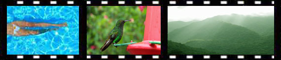
Climate: The weather throughout the province of Guanacaste is characterized by being hot with well-defined wet and dry seasons. The one exception is the highland portion of the province which consists of the upper Pacific-facing slopes of the volcanoes in the Guanacaste Cordillera and the northern half of the Tilarán Cordillera. The cool, moist conditions along these ridges support luxuriant cloud forests. Elsewhere, the natural vegetation type originally found in Guanacaste is (was) tropical dry forest.
This kind of forest extends from parts of Mexico down the western side of Central America to Costa Rica, where it reaches its southern limit in the general area of the Carara Biological Reserve. Due to the pronounced dry season that affects this habitat type for at least six months out of every year, fire works very well as a land clearing tool, and hence, most of the original forests have long since been removed for agricultural activities, principally cattle ranching. Thus, the noted tropical biologist, Dr. Daniel Janzen has described the Mesoamerican dry forests as "an endangered habitat." The parks and reserves in Guanacaste protect much of the remaining examples of tropical dry forest in the entire region.
The annual dry season is caused by the effects of the northeast trade winds that blow in off the Caribbean from November through March. This humid air loses its moisture as it crosses the Caribbean lowlands and the cordilleras. Given that the Guanacaste Cordillera is both the lowest and narrowest in the country, there is little to block the passage of the arid air that comes gusting down the western slopes drying out everything in its path, as well as preventing any breezes from bringing in moist air from the Pacific Ocean during these months.
When the trade winds shift northward, air currents once again bring humidity and life-giving rains in from the Pacific Ocean. It is remarkable to observe how quickly the parched and brown countryside regains its verdant appearance after the first showers of each new rainy season. In Guanacaste, these afternoon showers usually return by mid-May and continue until about mid-November.
History: The pre-Columbian inhabitants of Guanacaste are noted for the fine quality pottery that they produced. The variety of ceramic vessels found at archeological sites has led investigators to theorize the existence of a well-developed system of agriculture, and specifically grain production. The fact that as yet no evidence of hunter-gather societies has been unearthed in the region, has been a motive for speculating that the first humans to settle here already possessed a working knowledge of agriculture.
Indeed, the native peoples living in the area at the time of the Spaniards' arrival in 1519, the Chorotega tribe, were a group whose ancestors had emigrated south from Mexico. When Hernán Ponce de León and Juan de Castañeda sailed into what is now known as the Gulf of Nicoya on the last leg of their exploratory voyage from Panama, the name of the regional chieftan was Nicoya. Thus, the origin of the name of both the gulf and the peninsula.
During the first two decades of the Spanish Conquest in this region, the invaders established a lucrative trade: the sale of human slaves to Panama and Peru. This activity, together with untold deaths resulting from disease, decimated the local population.
Spanish settlement of Guanacaste was slow since most of the colonization from 1563 onwards was concentrated in the Central Valley and there was very little native labor force left in the lowlands to be employed in farming activities. The Spaniards brought in zambos, a mixed race of escaped black slaves and indigenous people from eastern Nicaragua and Honduras, to help work the haciendas in Guanacaste, but even so the population was too low to sustain much agricultural production. And so, cattle ranching developed as the most common activity in the region due to the low manpower requirements.
In the 1500's and 1600's, the primary revenue from cattle ranching was the sale of leather and fat to merchants in Panama. By the 18th century, a market for beef existed in Guatemala, but this meant a long and difficult cattle drive from the faraway ranches in Costa Rica. Nevertheless, ranching has persisted to the present day and was given a real economic boost in the 1950's and '60's with the development of the "hamburger connection" and North America's increased demand for cheap beef.
The other agricultural products of relative importance in the province are sugar cane and cotton, and since the late 1980's, with the creation of a large-scale irrigation program (the water comes from Lake Arenal after passing through several power generating stations), rice has become a prominent crop. Tourism, of course, is currently the region's most lucrative activity since Guanacaste is blessed by having many of the country's most beautiful beaches and its sun-drenched dry season coincides with the winter months in northern latitudes.
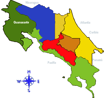
During colonial times, Guanacaste did not actually form part of the province of Costa Rica, but instead pertained to Nicaragua. Shortly after the nations in the region gained their independence from Spain in 1821, the residents of the communities of Nicoya, Santa Cruz, and Cañas decided that they preferred to become part of Costa Rica and announced their annexation on July 25, 1825. This date is commemorated by a government holiday, even though it was not until 1858 that the change in boundary lines was officially recognized and agreed upon by the two countries involved.
National Parks:
1) Isla Bolaños Biological Reserve
2) Santa Rosa National Park
3) Guanacaste National Park
4) Rincón de la Vieja National Park
5) Barra Honda National Park
6) Palo Verde National Park
7) Lomas Barbudal Biological Reserve
8) Las Baulas Marine National Park
9) Tamarindo National Wildlife Refuge
10) Ostional National Wildlife Refuge
Other Points of Interest:
1) Lake Arenal: This natural depression caused by local geological faults formerly contained a small lake that emptied into the Arenal River which flowed into the Caribbean via the San Carlos and San Juan Rivers. However, in the 1970's, the Costa Rican Electric Company (I.C.E.) began construction of what is currently the country's largest hydroelectric generating project.
An earthen dam was built only seven kilometers to the west of Arenal Volcano--that had erupted violently just a few years earlier. As the waters filled up behind the dam a thirty-kilometer long lake was formed. Water from the lake is tunneled to the Pacific side of the country, passing through three turbine-driven generating stations, before being channeled into a system of irrigation canals that have substantially increased the agricultural productivity of the lower Tempisque basin in Guanacaste.
As well as its importance for energy and agriculture, Lake Arenal provides excellent recreational opportunities, especially for windsurfing and freshwater fishing. The northwestern end of the lake is buffeted by strong winds, particularly from December through March, that make for ideal windsurfing conditions.
Fishing for guapote (Cichlasoma dovii), often referred to as "rainbow bass" even though it is not related to bass, is another popular sport on the lake. The season is open year-round (on this lake only) and there is a limit of 10 fish per day.
Daytime temperatures around the lake are pleasant all year long and evenings tend to be cool. The driest months are March and April. Lake Arenal is reached via the same roads that lead to Arenal National Park.
2) Geothermal Power Plant (Miravalles Volcano)
3) Eco-museum (Las Juntas): In the early part of the 20th century, gold mining was an important activity along the Pacific foothills of the Tilarán Mountains. Discovered in 1884, the mines near Las Juntas de Abangares were eventually sold to the North American entrepreneur, Minor C. Keith, the same person who built the railroad between San José and Limón. In their heyday, the mines employed nearly a thousand workers, but were also the scene of a violent labor dispute in 1911.
The Eco-museum was developed around the ruins of one of the oldest gold mines in the region where some of the old machinery, hand tools, and infrastructure can still be seen. The surrounding area is forested to a large extent and provides good opportunities for birdwatching and other nature observation.
The town of Las Juntas de Abangares is located 6 km. northeast of the PanAmerican Highway (the turnoff is 24 km south of Cañas). Drive through the town and follow the signs for the "Eco-museo", about 2 km. farther on. The museum is open from 8:00 a.m. to 4:00 p.m., Tuesday through Sunday. Phone: 662-0129 (in the Municipal Offices of Las Juntas).
4) Indigenous crafts manufacturing in the town of Guaitil: Continuing a tradition that predates the Spanish settlement of Guanacaste, the descendants of the Chorotega tribe living in the village of Guaitil still produce fine quality pottery. Having changed with the times, much the way the oxcart manufacturers of Sarchí have, the ceramic ware made in Guaitil is now destined mostly for the souvenir trade and is not so much a matter of creating vessels for daily usage. Nonetheless, it is still interesting to observe the process of making and decorating the variety of earthenware products.
To reach the village of Guaitil, take the road out of Santa Cruz to the east past the town of Santa Barbara (about 10 km.).
5) Cowboy Museum (Liberia): Known in Spanish as El Museo del Sabanero, the Cowboy Museum is a tribute to the hard-working plainsmen of yesteryear that are such an important part of Guanacaste's past and tradition. The museum showcases all sorts of memorabilia from old photographs to chaps and branding irons, and gives an insight into what life was like on the haciendas in times gone by.
Located 3 blocks south and one block east of the Municipal Building in Liberia, the museum shares space with the Liberia Cultural Center in a restored adobe house that was originally built more than 100 years ago. Hours are from 8:00 a.m. to 12:00 p.m., and from 1:00 p.m. to 4:00 p.m., Monday through Saturday. Phone: 666-1606.